Application Description
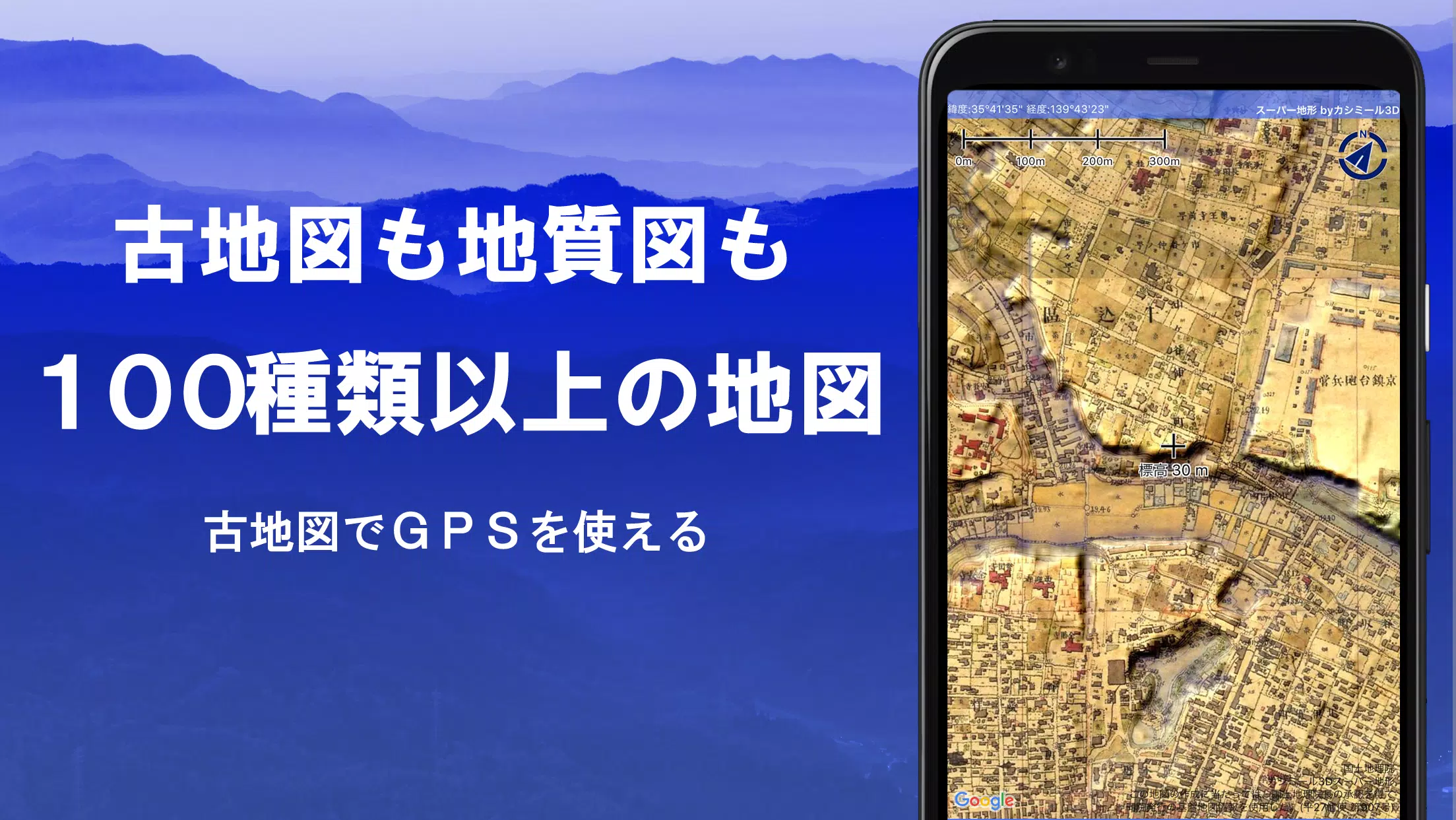
The Super Terrain app offers an extensive range of over 100 map types, including detailed maps from the Geographical Survey Institute, perfect for everything from mountain climbing to urban strolls. This powerful tool received the prestigious 2018 Japan Cartographic Society Award for Best Work, highlighting its excellence in mapping technology.
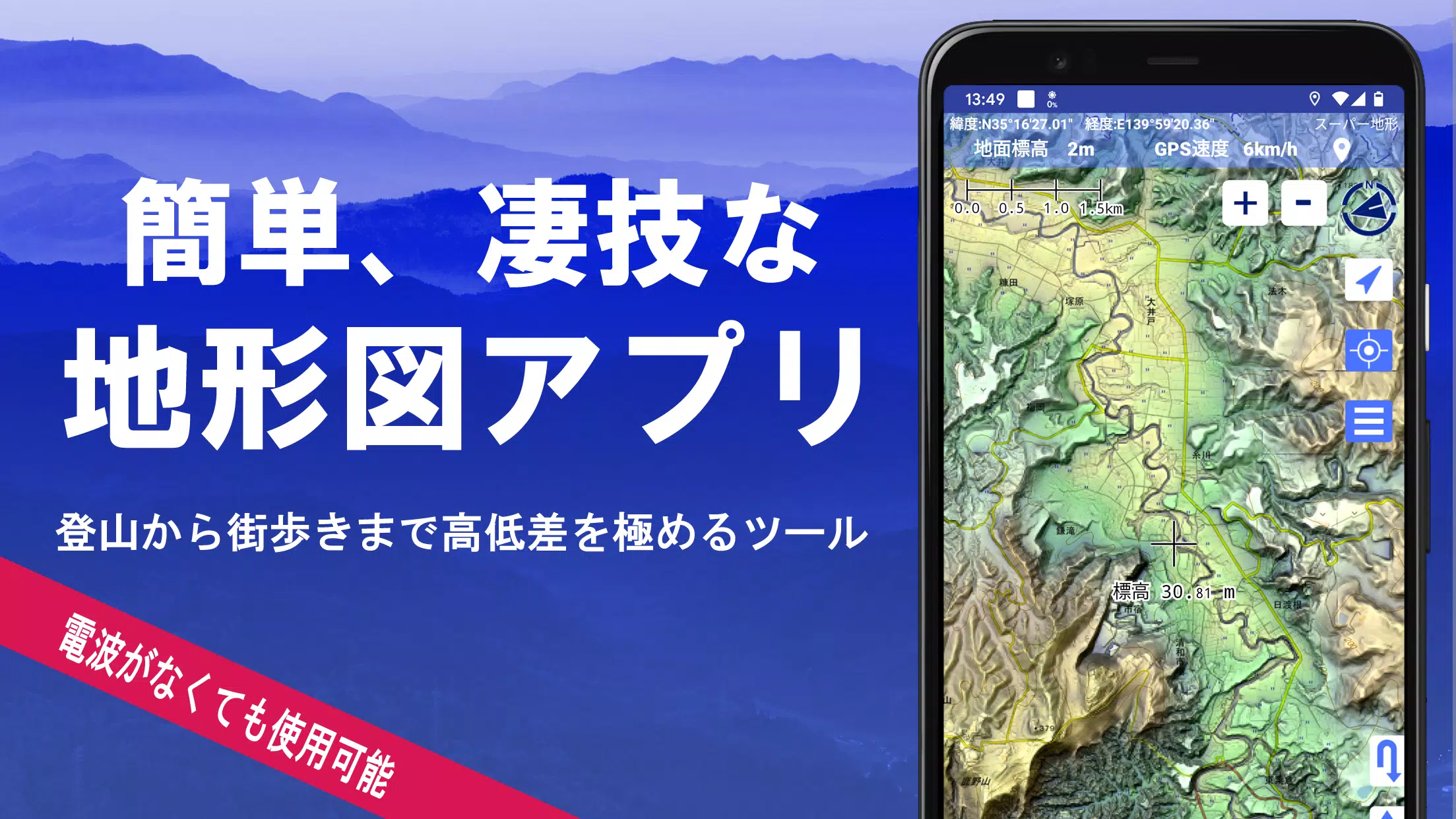
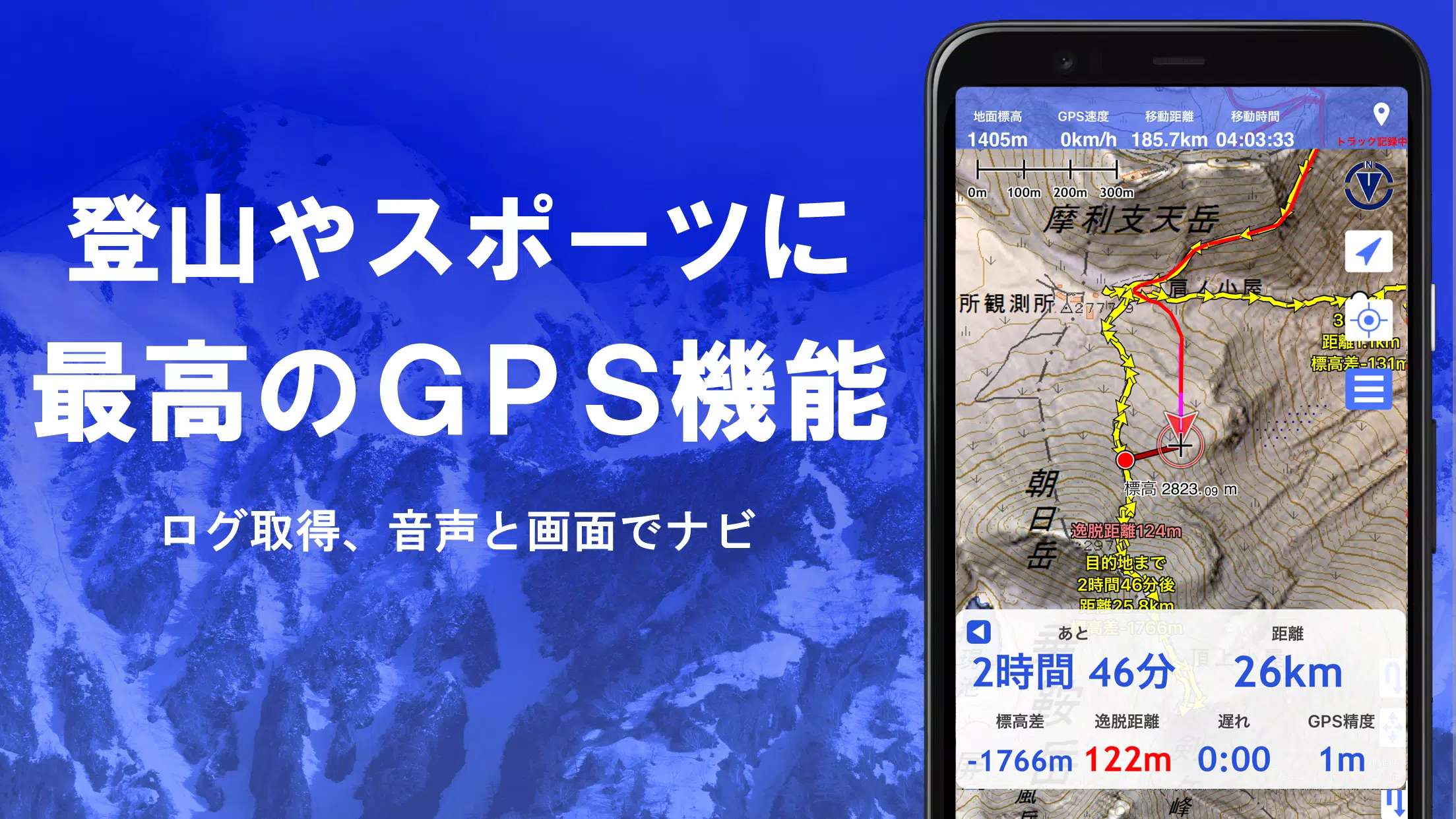
The app leverages "super terrain data" to emphasize and enhance terrain details, providing users with a rich visual experience. It also includes access to a variety of maps such as topographic, geological, historical, and prewar Ordnance Survey maps, all sourced from the Geospatial Information Authority of Japan. Users can record their tracks using the integrated GPS function, with options for GPX log input, output, and editing.
Designed to support a variety of outdoor activities, Super Terrain is equipped with GPS navigation, complete with audio guidance, as well as data recording and editing capabilities. It features a visibility determination function useful for creating cross-sectional diagrams, observing landscapes, and evaluating radio communication. The app also supports the display of buildings, enhancing its utility for urban exploration.
A 360° panoramic view function enables users to identify mountains by name, while also displaying the sun, moon, and GPS points. The app's robust offline capabilities include bulk map downloads and a map cache function, ensuring reliable use in remote areas without radio signals. Users can associate photos with specific points on the map, and display contour lines generated from elevation data, as well as MGRS grids.
Super Terrain supports the reading, displaying, and editing of GIS data from GeoJSON files, and allows for the drawing of shapes. Its versatility extends to international use, with options for map printing and PDF output, and a user-friendly dark theme.
1. A Wealth of Maps That Can Be Used
Super Terrain boasts an impressive collection of more than 100 map types, including combinations of our proprietary super topographic data and maps from the Geospatial Information Authority of Japan. Aerial photographs are available by age group, with coverage varying; "Latest" and "around 1974" provide extensive coverage. Notably, maps using super terrain data are available for free for the first 5 days after app installation.
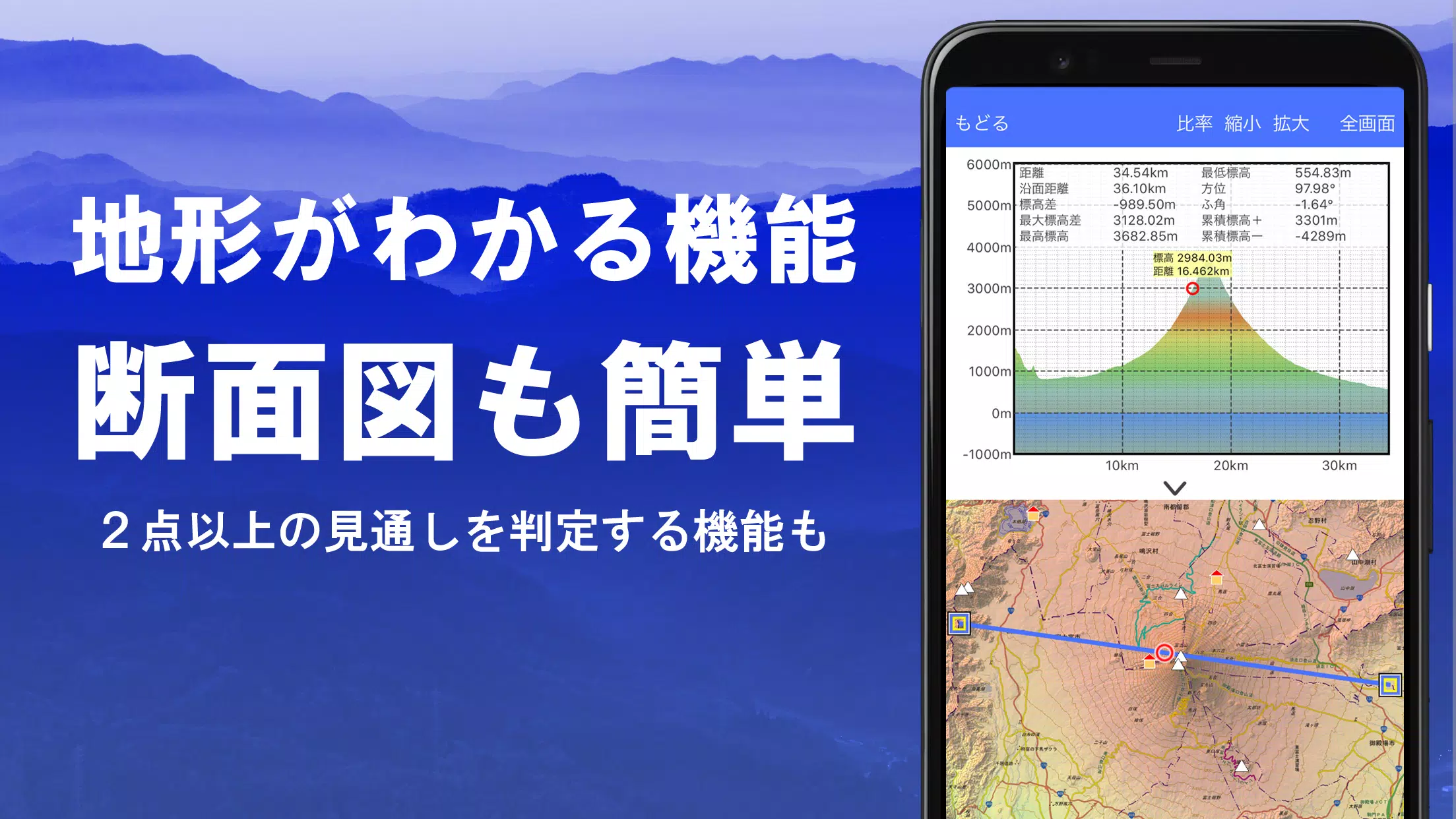
2. Creation of Cross Sections and Outlooks
Easily draw cross sections through any point on the map with Super Terrain. The app's visibility judgment function, familiar to users of Kashmir 3D, accounts for Earth's curvature and atmospheric differences, making it invaluable for route planning during mountain climbs, assessing radio visibility, and understanding terrain. Where PLATEAU building data is available, you can generate cross-sectional views that include buildings.
3. Elevation Palette Function
The elevation palette function allows you to customize the map background color, adjusting it to your preferred gradient in 1cm increments, enhancing your map viewing experience.
4. Panoramic View
Explore a panoramic observation map that displays mountain names from any location on the map. The 360-degree panorama integrates with your smartphone's compass, making it an excellent tool for mountain identification. The app also shows the sun and moon, including lunar phases, which can be used to discover Diamond Fuji and Pearl Fuji sightings. Additionally, it supports viewing GPS points and creating panoramic views of mountains abroad.
5. GPS Function
Utilize your smartphone's GPS to obtain location information and record tracks with high precision, ideal for serious mountain climbing and outdoor activities. The app graphically displays recorded tracks with parameters such as elevation gain, speed, time, and elapsed time. A point alarm function alerts you with voice and sound when you approach a designated point. You can also view photos associated with points and send the map center position to NaviCon.
6. GPS Track Summary Playback
The GPS track summary playback function allows you to review your tracks in full. It automatically displays photos from your smartphone that match the recorded times, with icons at photo locations that you can tap to view.
7. GPS Navigation Function
Navigate along preset tracks using the Track Navi function, which alerts you with voice or sound if you deviate from the track, ensuring you never get lost while climbing. The app also supports route navigation for urban exploration and point navigation for reaching specific locations.
8. GPS Data Editing Function
Super Terrain manages GPS-related point, route, and track data, organizing them into folders and displaying them in an easy-to-read tree format. You can create tracks directly on the map, and import and export data in GPX format from mountain climbing sites.
9. Map Usage Outside the Service Area (Offline)
Continue using maps even in remote areas with no signal thanks to the bulk download function, which allows you to download all scale maps of a specified area. A visual indicator shows what maps are being downloaded, preventing any surprises at your destination. The cache function further enhances offline usability.
10. Map History Function
The app remembers locations you've viewed, allowing you to quickly return to previous spots.
11. Custom Map Compatibility
Import and use custom maps created with Kashmir 3D's map cutter, displaying your own maps and scanned images. Ensure each image is divided into approximately 256 x 256 pixels, and send the resulting kmz file to Super Terrain via email or Cloud Drive.
12. GeoJSON Compatibility
Display and edit points, linestrings, and polygons from GeoJSON format files, with the ability to draw new shapes.
13. Print/PDF Output
Print any area of the map at a specified scale or generate a PDF for easy sharing and reference.
14. Cooperation with Other Apps
Input and output GPS data in GPX, KML, and GDB formats, facilitating data exchange with other apps, the Kashmir 3D software on your PC, and trajectory data from mountain climbing sites.
15. Backup Function
Backup all app data (excluding cached maps) and remove it from your smartphone, ensuring you can restore it even if you delete the app or experience a device malfunction. An automatic backup feature using Google Drive keeps your data up-to-date. Refer to the manual for detailed instructions.
16. About Billing Function
Some features, including maps using super terrain data, GPS track functions, and cross-sectional views, require in-app purchases. After payment, you'll enjoy an increased number of search results for place names.
●Fees: Annual payment of 780 yen/year.
●Free Trial: Try the app for free for 5 days after installation. After this period, some features and maps will be unavailable unless you complete a purchase. Charges only apply if you actively purchase within the app.
●Confirmation and Cancellation: Manage automatic updates or cancel them via Google Play under "Regular Purchase" and selecting "Super Terrain."
●Price Revision: Future feature enhancements may lead to price revisions, making early purchase advantageous.
17. Terms of Use
The copyright holder and developer are not responsible for the outcomes of using this application. Upon first use of GPS, allow location services when prompted. Be aware that continuous GPS use drains the battery; carry a spare for emergency communication devices. A detailed explanation of the navigation function is available in PDF format at https://www.kashmir3d.com/online/superdemapp/superdem_navi.pdf. Note that some smartphones may interrupt or fail to record tracks due to power-saving features that close background apps, a common issue across various apps. Temporarily turning off the screen can help maintain recording, but it's not a permanent solution.
Screenshot
Reviews
Apps like スーパー地形 - GPS対応地形図アプリ


Trending apps


Top News


Latest Apps


Latest Articles